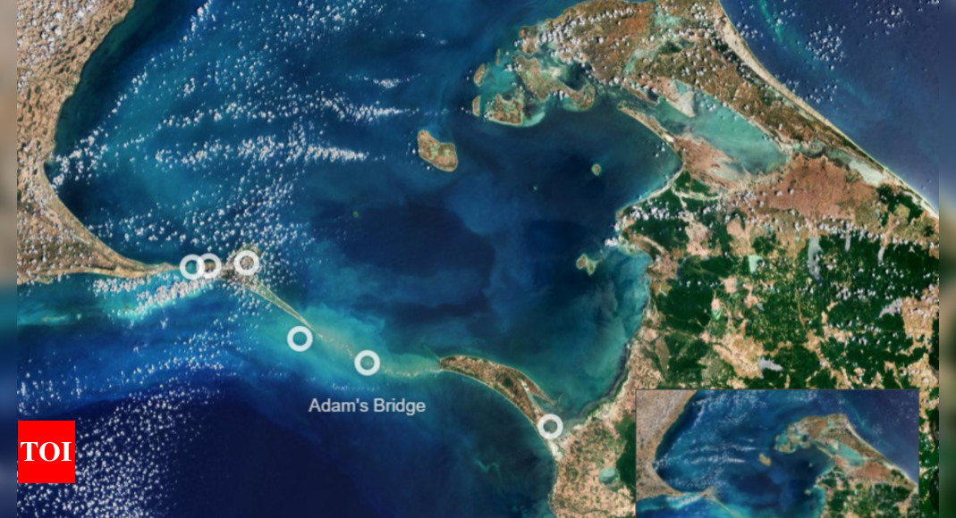
The European Space Agency has released an image of the Ram Setu , also known as Adam's Bridge , captured by its Copernicus Sentinel-2 satellite .This chain of shoals links India and Sri Lanka , stretching 48 km between Rameswaram Island, off the southeast coast of India, and Mannar Island in Sri Lanka.
It separates the Gulf of Mannar, an inlet of the Indian Ocean to the south, from the Palk Strait, an inlet of the Bay of Bengal to the north.There are numerous theories about the formation of this bridge.
The island's two main towns are Pamban, on the western edge, and Rameswaram, approximately 10 km east of Pamban.Both sections of Adam’s Bridge are part of protected national parks in their respective countries.
The sand dunes serve as breeding grounds for birds such as the brown noddy, while numerous species of fish and seagrasses thrive in the shallow waters.
The sea life around Adam's Bridge includes dolphins, dugongs, and turtles.
The European Space Agency has released an image of the Ram Setu , also known as Adam's Bridge , captured by its Copernicus Sentinel-2 satellite .This chain of shoals links India and Sri Lanka , stretching 48 km between Rameswaram Island, off the southeast coast of India, and Mannar Island in Sri Lanka. It separates the Gulf of Mannar, an inlet of the Indian Ocean to the south, from the Palk Strait, an inlet of the Bay of Bengal to the north.There are numerous theories about the formation of this bridge. However, geological evidence suggests that these limestone shoals are remnants of land that once connected India and Sri Lanka.Historical records indicate that this natural bridge was traversable until the 15th century, after which it gradually eroded due to storms over the years, the ESA said.The European Space Agency noted that some of the sandbanks in the Ram Setu are dry, and the sea in this area is very shallow, ranging from only 1 to 10 meters deep, as indicated by the light color of the water.Mannar Island, covering around 130 square kilometers, is connected to mainland Sri Lanka by both a road bridge and a railway bridge, which are visible at the southern end of the island.On the Indian side of Adam's Bridge, Rameswaram Island, also known as Pamban Island, can be accessed from the Indian mainland via the 2-km-long Pamban Bridge. The island's two main towns are Pamban, on the western edge, and Rameswaram, approximately 10 km east of Pamban.Both sections of Adam’s Bridge are part of protected national parks in their respective countries. The sand dunes serve as breeding grounds for birds such as the brown noddy, while numerous species of fish and seagrasses thrive in the shallow waters. The sea life around Adam's Bridge includes dolphins, dugongs, and turtles.